
Overview:
For this assignment, students used primary source accounts to locate christianization efforts on and beyond the frontiers of the Roman empire. It was originally conducted in Andrea Sterk’s history course, HIST 1081W/3081W (cross-listed with religious studies and medieval studies): Martyrs, Monks, Crusaders: World Christianity, 100-1400 (syllabus here). The course had 4 discussion sections with about 20 students each.
Each student was assigned to one or two of 8 primary source accounts by their respective TA and had to submit a reading response via the online program Survey123. This survey required students to answer a set of standard questions on Christianity and christianizing activity in a particular region based on the relevant account(s), but it also had them attempt to locate the geographical setting mentioned or implied within the primary sources.
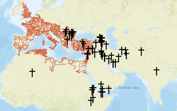
The students’ combined responses created a geographic data layer that displayed where they had located each of their assigned sources. Using this data, an academic technologist created a web-application to display these christianization efforts in relation to the Roman Empire (in this case, symbolized by its road network). The resulting map can be found below (note the data layers on the upper-right corner are divided by TA sections):
Resources Available
- Assignment given to students (PDF) (includes source list and survey questions)
- Survey as seen by students (PDF) (please do not submit any answers!)
- Mapping Christianization on the Ancient Roman Frontier (finished map project)
- Syllabus for Martyrs, Monks, and Crusaders Course
Outcomes and Notes:
-
- Students had to read the primary sources for relevant geographic information, resulting in closer engagement with sources.
- Pinning ancient accounts to a single location is, naturally, quite difficult. This exercise made students grapple with the difficulty of establishing geographic context to often vague ancient sources.
- Several students that were assigned the same sources managed to choose drastically different locations. This highlighted both modern difficulties to make sense of ancient geographies and the vague geographic understanding of ancient authors themselves.
- This assignment took relatively little time on the student end, but was rather involved for the instructor and academic technologist.
- Unless the instructor or one of the TAs has some training in ArcGIS technology, it is advised that an outside academic technologist build the map using the survey data.
- Finally, even if you cannot construct a map using ArcGis or similar technology, the exercise of having students read and answer a set of questions on diverse sources on Christianization–from different locations in roughly the same period–is very worthwhile. It led to some interesting comparisons and contrasts and and a fuller picture of mission, conversion, and Christianization and the various types of people involved in these historical processes.
Note: To use Survey123, your university needs a subscription to Esri GIS software. Ask your libraries or academic technology support if this is available.
Structure:
- The assignment took place over a 2 week period, which began with an academic technologist introducing the assignment prompt and survey to the students. Instructions were given on how to draw out relevant geographic information from the sources.
- Students submitted the survey a week later and the academic technologist built the map.
- The TAs displayed the map in their respective sections and had students respond to it and discuss the nature and agents of Christian expansion in each of the regions studied.
Collaboration by Andrea Sterk and U-Spatial at the University of Minnesota for HIST 1081W–Martyrs, Monks, Crusaders: World Christianity.
- U-Spatial Story Map Curriculum Portal–more examples and resources for students and instructors